A Brief History of the Washakie National Forest and the Duties and Some Experiences of A Ranger
ANNALS OF WYOMING
Vol. 4 October, 1926 No. 2
A BRIEF HISTORY OF THE WASHAKIE NATIONAL FOREST AND THE DUTIES AND SOME EXPERIENCES OF A RANGER
A. G. Clayton, Forest Ranger
Sheridan District
On the eastern slope of the Wind River Range in Fremont County extending almost its full length, embracing some of the largest bodies of timber and most rugged and scenic parts, lies the Washakie National Forest. Roughly, 865,000 acres of mountain land. It furnishes railroad ties, lumber, and wood; water for domestic and irrigation purposes; summer pasture for thousands of head of cattle and sheep, besides, feeding grounds and shelter for large numbers of the varied wild life of the state. Covering as the area does, so many things of vital interest to the people of this and other communities it only seems fitting to give an outline of its history, value, and use. Consequently, in order to make this article of some historical worth it is necessary to go back a number of years and commence with the beginning, in so far as related to man.
From all accounts available, the area was not used to any noticeable extent by the early Indians. Game and feed were plentiful in the lowlands and there was little need for the Indians to venture into the mountains for these or any other purposes. While there are several places at which Indian wall writings have been found, they are all at points well down from the mountains themselves, such as in the lower Dinwoody Canyon.
Undoubtedly the earliest users of the Washakie Forest were the so-called sheepeaters. They were renegade Indians, who, for the sake of safety and perhaps convenience, coupled with the age old fellowship of man, banded together where possible and lived their lives in the mountain fastnesses. They had evidently violated various tribal laws and did not belong to any fixed tribe, having been compelled on penalty of death to live as fugitives. At times they preyed upon small parties or lone Indians for the purpose of equipping themselves with such implements or weapons as were obtainable, or possibly to steal a squaw, returning at once to their mountain retreats. They were not warlike but were supposed to have been cowardly and shy, which, under the circumstances is easily understood. Plainly they were social outcasts.
The name sheepeater is somewhat of a misnomer. There is no reason why they could not just as well have been called elkeaters or deereaters. Perhaps fish and wild fowl formed an important part of their living because they no doubt found it easy to procure fish and other small game. In any event they lived on the land as best they could and did not, as might be imagined, live solely on mountain sheep.
Naturally their hunting methods were crude as compared with the present. Frequently traps were used. These took the form of log or stone fences generally placed at points frequented by game. The idea was that game, while feeding or trailing and being unmolested would encounter one of these fences and would then turn and follow the line of least resistance along the fence, rather than exerting itself to jump it. Another fence leading at right angles would at a point converge with the first near which points hunters with bows and arrows would be concealed. Or perhaps instead of the two fences converging an opening would be left through which the game could pass. But the opening would probably lead out onto a ledge over which game could not go and they would then be rushed from behind. The remains of such as this can be found on the east wall of the West Fork of Torrey Creek near its mouth. There are many points throughout the northern parts of the Forest where parts of these ruins can still be found.
Several theories are advanced as to the final disappearance of the sheepeater. One is that diseases of various sorts entered their ranks; another that tribal Indians destroyed them, but it appears that the most likely one is the coming of the white man, who, in subduing their enemies the lowland Indians, made it possible for them to return to their former homes and take up the life of the normal Indian. It is said by some that a few still are living on the Wind River Indian Reservation. In any event these people can justly be considered as the first users of the Washakie National Forest.
It is not my intention to go into a long discourse on all of the various hunters, traders, explorers and such who first passed through or resided in this part of the State. These points have been well covered by others and space would hardly permit. Furthermore this article is mainly about the mountains and I will try not to deviate from that course.
Something has previously been written concerning the party of Frenchmen under De La Verendrye, which, in 1743 is supposed to have traveled up the South Fork of the Shoshone and crossed over to the Wind River. Following the route that they did it would have been possible for them to cross only at what is now called Shoshone Pass which is on the head of DuNoir River, a large upper tributary of the Wind River. DuNoir, meaning "the black" was probably named by these Frenchmen as they looked from the Pass and were at once struck by the large, and at a distance, black body of lodgepole pine which extends throughout this watershed. No doubt this sight prompted the name. These were the first white men to enter the region.
The name of John Colter seems to be deeply inscribed in early Wyoming history. He and his companions Hancock and Dixon, the first Americans to enter this part of the State, evidently traveled over what is known as Twogwotee Pass on their trip to Yellowstone in 1808. Twogwotee, at one time spelled "Togwoda" or "Togwater" means the spear. This pass is one of three main passes in the upper Wind River Range used by early travelers and still in use at the present time. An old Indian legend has it that at this point a food cache was kept at which Indian travelers could replenish their supplies while traveling through.
In passing a few points of particular interest might here be recorded relative to Twogwotee Pass. In 1873 an expedition was sent out under a Captain Jones to report upon a good route for a road into Yellowstone Park. Three routes were explored and this one was chosen as by far the best. In his report Captain Jones said that a railroad grade could be laid without the tremendous expense incident to other locations. Not until 1898 was the road built and then by the army and was made passable to wagons. It was pointed out as a model road at the time in spite of the fact that one of the hills was so steep that, to paraphrase one of the old timers, wagons had to be let down by means of a windlass. But the most interesting thing about it is that this road which followed the route reported on in '73 as by far the best, was not built until after all of the others had been constructed. It was not completed until 1922.
Not many miles to the south of Twogwotee Pass is Sheridan Pass, named in honor of General Sheridan who crossed it as head of the military escort of President Arthur in 1882 or '83, on the occasion of Arthur's visit to the Park. The exact date is not available.
In connection with Sheridan's trip it might be interesting to note two happenings during their journey. At least they show some of the personal side of both Arthur and Sheridan and the originality, humor, and independence of the early Wyoming cow-puncher and soldier.
Word had been telegraphed north from Rawlins that the presidential party was enroute and traveling with a military escort from Green River City. Two cowpunchers near Rongis had heard of the party coming, and being desirous of seeing the president had ridden out to meet it. At a point near South Pass they met, the cowboys having since been joined by a few others.
Sheridan and Arthur were in a Concord coach and the first thought that the president had upon seeing the cowpunchers was that he was the victim of a hold up. Upon being told the visitors mission, Sheridan, who was in civilian clothes at once dismounted from the coach and introduced all hands to the president. Then they decided to camp and have a sociable time. A regular banquet was held and all formality was thrown to the winds. Since it was early morning when the parties met much time was so spent. A shooting match was held; hats were thrown up and shot at and likewise cards. Sheridan proved himself expert with the revolver and since the president had never seen a real bucking horse one of the men gave a splendid exhibition in riding.
Later, on entering the mountains to the north, the president offered a prize of twenty-five dollars to the soldier catching the largest trout. Several tried for the prize but with no success. The fish were all too uniform and there was not enough disparity in their sizes to make the contest exciting. The interest of the men waned.
One of the men whose first name was Paddy thought that he needed the twenty-five, and, moreover, he was going to have it. Shortly after making this resolution he was very successful and presented the cook with a fish which weighed a fraction less than twenty-five pounds. But the strange part of the whole thing was that the fish was little, if any, larger than the general run. "True enough," said Paddy, "he was little larger as far as appearance was concerned but nevertheless he was well built and solid—very muscular. Just heft of him and see!" A post mortem of the fish was held a short time later which disclosed the fact that it had either eaten, or absorbed in some strange way, a large quantity of leaden bullets. Needless to say he was given the Presidential prize.
In the summer of 1925 near Sheridan Pass was found an old Colt "Walker" model caliber .44 revolver. It was completely covered with earth, except a small part of the butt which projected a short distance above ground. This was made between 1838 and 1842 and was considered very successful by the Federal Government during the Seminole War. Very likely it has an interesting history.
Ten miles south of Sheridan is Union Pass. As far as the popular conception of a mountain pass goes this is indeed a surprise. One can hardly tell when the pass has been crossed because the whole surrounding country is so rolling and level. There are several miles of this kind of country in the immediate vicinity. The W. P. Hunt expedition crossed here in 1811 and mention was made at the time of the many plain trails leading through that way. It is possible that these were game trails. Local opinion has it that the first wagon taken over the Pass was in 1901 by way of Little Warm Springs Creek just west of Dubois. I doubt the authenticity of it. It is possible that the Hunt Expedition had wagons which would discredit local opinion as it now stands. With the early explorers and settlers, so with some of the points near the Forest, there are so many of historical interest that space will not permit of their discussion. South Pass for instance, the cradle of woman's suffrage, has been the source of much comment. The early developments there in mining have done much to stir the blood of the past and present generations. So much has been written in regards to this place that it would be inconsistent to here record similar happenings.
Two years ago while in the South Pass country I happened to stumble onto an interesting relic of the placer boom near Atlantic City in the early 80's. It was at Louis Lake well back in the mountains from South Pass City. On a tree and close to the shores of this lake at a point well isolated from travel, I came upon an old sign which bore this inscription: "Louis Lake August 1884." It was very striking as small things go. The letters and figures which had been perfectly made, had been incised on an old piece of lumber and painted black. The board was knotted and rough and it surely required skill to do the work as well and neatly as it had been. I later found that the sign had been made in Atlantic City during the winter of 1883 by the engineer then in charge of the Granier Ditch. The ditch had, in many places, gone the way of most things but the small sign still stood after forty years of exposure to Wyoming mountain weather, easily readable, as evidence of careful work well done.
Gradually, as the west settled, the American people began to give serious thought to their natural resources. The shortage of timber in the east and the middle west was beginning to be felt. Careless logging was beginning to be everywhere condemned and people viewed with horror the yearly toll that fire was taking, since little organized effort was directed at preventing it, much less combatting it. The conservation movement grew rapidly and in this way took form.
In 1891 President Benjamin Harrison issued the proclamation establishing the Yellowstone Timberland Reserve. This was one of the first "reserves" established and at the time embraced most of the timbered land in western Wyoming. The present Washakie Forest was then part of the Yellowstone Reserve which at the time amounted to little more than the proclamation forming it, since the directing organization was then in its formative stages. This territory covered both slopes of the Wind River Range. On July 1, 1908 the name of the Wind River Division was changed to the Bonneville Forest in honor of Captain Bonneville who first came in sight of the Wind River Mountains in 1832.
Until 1907 these forests had been called "forest reserves" but it was generally understood that this was a poor name for them. The old "Use Book" made it clear that they were for use and everybody from the president on down had said the same. Consequently in 1907 "forest reserve" was superseded by "national forest" which is more appropriate, since they are not and never have been "reserves" in the full meaning of the word. This has the additional advantage of distinguishing between state and federal forests. Unfortunately due to the early usage of the name many still refer to them as "forest reserves."
Further changing conditions due to the increase in settlement in the adjoining country put additional demands upon the first personnel and again made it necessary to reduce these large forests to smaller. On July 1, 1911 the Washakie National Forest was formed from the southern part of the Bonneville; that part which lay south and west of Lander. On July 1, 1916 another change was made, some of the western part of the Washakie being added to another forest, while the remaining Bonneville was added to the Washakie. This gives all the Wind River drainage to the Washakie National Forest which brings us down to the present.
The forest can be divided into two main parts, the upper Wind River watershed and the Popo Agie, which is south of Lander. Of course there are many other streams, but these two, later converging into the one Wind River, can be considered as the main arteries. They are fed by many lakes and glaciers which blanket the continental divide and lie in the most rugged and inaccessible parts of Wyoming. Many of the highest peaks of the state are within this area and one of the largest glacial fields within continental United States. This high country presents one of the most spectacular arrangements of mountain scenery in the west. Having viewed it from some lofty eminence one never forgets the thrill.
The most prominent timber type is the lodgepole pine, lodgepole because the early Indians used them in constructing their tepees. And well they should, for I know of no tree better suited for the purpose naturally than the lodgepole. It is remarkably clear of branches for a long distance up the trunk and grows very straight and tall. It might be compared to a tall slender flower as a giant would see it. Its needles always grow in clusters of two.
There are other species, the most prominent being the Engelman Spruce. Then there is the Douglas Fir and the limber pine, both of which grow promiscuously over the whole forest, tho none to the extent of the lodgepole. All of these trees, except the limber pine, are valuable for ties and lumber, the limber pine frequently can only be used, if used at all, for fuel wood.
Of some of the smaller species, that is, smaller, in this country, we have the juniper and the aspen. The "old maid of the mountains" the aspen is frequently called due, I believe, to its gently quaking leaves. If such a similarity exists I most humbly bow to the spinster. Of little commercial value, it is to me one of the most beautiful trees in Wyoming. It grows in groves and at low elevations and in the fall its trembling leaves dipped in silver and liquid gold cast and reflect visions of fairyland. At that time of year, aspen, against the somber pines, give contrast where contrast is most needed.
There are many parks scattered here and there throughout the timbered portions which furnish pasturage to livestock. Grazing permits are issued to qualified owners of stock and local residents are given first preference for range so allotted. In looking back it is found that grazing permits were first issued in 1903, free of charge, and payments were not called for until 1906.
For the purposes of efficient administration the forest is divided into three districts with a ranger in charge of each. These districts are the Absaroka, Sheridan, and Lander. The district ranger assumes full responsibility for his territory and answers directly to the forest supervisor at Lander. Topography plays an important part in the selection of district boundaries as well as the quantity of work or activities necessary to good administration. One district may have considerable timber sale work while another has much grazing, or heavy tourist travel which would make it necessary for the ranger to give correspondingly careful attention on account of likelihood of fires. Or perhaps there may be a combination of all. Such is the case on at least two of the districts of this forest.
Since the timber is the most important part of any forest, it naturally develops that the protection of this is the ranger's main work. This takes precedent over everything else. And is there any need for me here to record the many values of timber? So much has been said concerning it that I feel as though such statements here would be uncalled for. But I might say that on the Washakie we have already a good market for the timber grown which no doubt throws the realization of its value a little closer home.
In order to omit too much generalization I am going to take one district, the Sheridan, with which I am very familiar, realizing that which applies to it applies to the rest of the forest. It is sixty miles long and varies in width from eight to twelve miles and contains approximately 375,000 acres, a fair sized piece of country you must admit. Very likely there are as many different interests making use of this area as can be found in any other similar mountain region of the west. Here is found some of the finest railroad tie timber in the state, and the present largest company in Wyoming producing ties. Here is the beginning of the big game section of Wyoming and the home of the most lofty peaks in the Wind River Range which means the entire state. Here we find lumbermen, stockmen, and recreationalist side by side putting a forest to its fullest use. But the timber, as was said before, is our main concern.
The cutting of ties here has been in progress since 1914. The timber is bought from the Government by competitive bidding after advertising. There have been a number of sales of timber or "sales" as we call them, but almost all to the same company. The company is known as the Wyoming Tie and Timber Company. From 1914 to the spring of 1925 there had been over 4,000,000 ties taken out, to say nothing of thousands of mine props and fence posts. This is a good sized output and ranks well up with tie production in other parts of the west.
The areas worked are so large and the amount of timber cut is so great that it is handled as a separate project, with a lumberman, Mr. E. H. Peck, in charge. There are also several assistant rangers employed yearly in order to help in the administration of the sale. It would be out of the question for the district ranger to assume this responsibility.
The operations at present are confined to the DuNoirs, both east and west, and have been for several years past. The ties are cut in the fall and winter and hauled during these periods to points on both of these streams, known as banking grounds, where they are decked in piles from eight to twenty feet in height. They are so arranged that a ranger can always get at one end of a pile and count the number of ties in it and stamp them. This is done with a hammer bearing U. S. in raised letters. As each tie is counted it is struck on the end with the hammer. In this way the ranger can check them over and see that all have been counted.
At high water time in the spring the ties are thrown into these small streams and driven to the mouth of DuNoir where a cable "boom" holds them from drifting on into Wind River. As soon as the bulk of the high water has gone out of the Wind River the boom is opened and the big drive is on; approximately ninety miles by water to Riverton. It is a hazardous undertaking for a freshet may occur at any time which would scatter the ties all over the bench land along this stream. Getting the ties back to the stream is very expensive to the company, as a matter of fact in 1923 the stream raised eight feet in two hours while the drive was in progress, causing a loss of 12,000 ties.
The first drive made on Wind River was made in 1906 with J. D. Stewart of Dubois in charge. This was of logs which were to be sawed at Riverton. Little trouble was experienced on this drive except that gravel and small rocks lodged in the ends of some of the logs making sawing difficult. Mr. Stewart claims that this did not affect them as much as might be imagined and the reason why driving here was discontinued was that the following year the railroad built in which made it possible to get lumber cheaper by rail. However, log driving in Wind River was a failure.
The first tie drive was from Wind River in the spring of 1914 and included over thirty-three thousand railroad ties and several thousand mine props and fence posts. The last drive, in the summer of 1925, contained over six hundred thousand ties and there is a possibility of a drive very nearly as large for 1926. This locality has some distinction as being known as one of the few remaining places in the United States where river drives are still in progress.
In these tie operations many trees are cut, naturally, and in all cutting operations on a national forest green timber must first be selected and marked by a forester. On a sale of this size a regular marking crew is selected from future district rangers and men who have had some previous experience in a ranger's training school or forest school. In this particular case there are generally four men on the crew who work in strips or sections, back and forth across a certain unit. These men are directed and supervised by the lumberman in charge of the sale.
The marking is done with a hatchet, bearing U. S. in raised letters on the head. A blaze is made low down on the stump and stamped U. S., then a similar blaze and stamp is made on the trunk at a distance above ground that can easily be reached. The lower mark is a cheek when inspections are made and serves to readily tell that only selected trees have been cut while the upper blaze directs the cutter. All trees above a certain diameter are selected as well as defective, diseased or insect infested trees.
Contrary to popular opinion "brush" is not piled except along well traveled roads or trails. Piling was practiced for a number of years but the expense incident to piling and burning did not seem to be justified. Now branches are lopped full length and left where they fall. While the logs are being moved the brush becomes scattered. This is called the "scatter" system of brush disposal.
A forty year cutting circle is being established in this locality which when the final plans have been completed will ensure a permanent tie industry. Briefly it will mean the cutting of a certain number of ties equal to the annual yield and sufficient always to supply a good sized demand. When one watershed is cut over the work will move to the next in line, leaving in each place a good healthy growth of immature trees for the next cutting forty years hence.
The selling of recreation seems to be one of the big coming industries in Wyoming. Recreation to he profitable is dependent on scenic attractions, and, they are very numerous in this part of the forest. Annually visitors come from this and many other states and catering to their wants is becoming a remunerative line indeed. While so many people in the woods during dry periods add to the fire hazards, nevertheless it is a condition which is met and handled as broadly as possible. Aside from the commercial value to those supplying the wants of the tourist the asthetic value to the tourist himself cannot be measured in dollars and cents. No one can live amongst nature's own wonders such as are here without being a better person from the experience. People are the most important thing that a country has and to build up their health, heighten their ideals, and strengthen their hopes is a great thing indeed.
Experience in many lines has proven the value of being prepared. With this in view the district ranger spends much time during the winter planning for the suppression of fires. For him to wait until a fire starts and then make a confused effort to plan his suppression is bad, it is worse, it is the height of imbecility and would not nowadays be tolerated a second. A very complete, concise, and simple plan is arranged. Charts are made, "organization charts" we call them, on which the names of men who can be depended upon are listed as foreman for crews, for timekeepers, cooks and packers and together with all sources of labor supply. Leaders or "key men" who can be depended upon to take initial action without additional orders from the ranger are personally seen and lined up and given to understand clearly what is expected of them.
Maps are prepared showing the locations of food and tool caches, telephone lines, ranches, camps, routes of travel, and anything else that may be of use in combatting a fire. The plan is complete and thorough, yet clear and condensed; so simple, in fact that almost any stranger could step to a telephone in a ranger's cabin, consult the chart and maps which hang near it, and so organize in a few minutes a good sized crew of men, food, and tools and furnish their transportation and have them on the way to the fire in almost as short time as it takes to tell it.
Right here it had best be said that co-operation with local people is the key to our whole fire fighting organization. Without it we would get nowhere. Without the willingness of the local people to respond and align themselves in accordance with our organized plans, even as is generally the case in dropping their own important duties for the time being, forest fire suppression would fail. The ranger alone can do little. He may be many miles away at some distant point of his district entirely unaware that a fire is starting. He would be the same as a captain without his company—as capital without labor. He is purely the directing force and on that he stands or falls.
A fire lookout station is maintained on a ridge leading up to the Pinnacles, that range of rugged peaks which are located just north and east of Brooks Lake. It is simply a tower on which is placed a square house or observatory with windows on all four sides. The house is oriented properly with cardinal directions. A small cabin two hundred yards below serves as quarters for the lookout. Both tower and cabin are connected by telephone with Sheridan Ranger Station which is seven miles away.
In the center of the observatory is a table on which is placed a map of the area observed. Radial lines are drawn from the point showing the location of the lookout through each fifth degree of a complete circle. Similar maps are at all ranger stations in the northern part of the forest. On the wall of the observatory is the regular district plan such as was discussed in preceding paragraphs.
A peep sight alidade is swung on a pivot from the point where the radials converge, and at the instant smoke is seen arising the lookout can tell exactly the direction which it bears. The distance from the lookout outward on the line along which the smoke bears has to be estimated, but this is not difficult to one as familiar with the country as the lookout is.
The lookout goes on duty at the beginning of the dangerous fire season which here is generally the first of July. Sometimes the fire season starts before this date but never later. He remains on duty until such time as the main fire danger has passed which is generally about September 10. It is a lonesome job, this fire lookout's, and it requires a man who can be satisfied and happy without sight of or communication, except by telephone, with any of his kind for many days at a time. It is out of the question for him to leave his tower during daylight hours in periods of extreme fire hazard. He is there to stay since much depends upon his keen observation and constant vigil. The lookout, like local co-operators, is one of the main stays of the fire organization.
Let us take a concrete case.
It is two o'clock on a hot and dry afternoon in August. The warm summer winds have drawn every vestige of moisture from the mountains of timber. The whole organization is on its toes and keyed up to be ready for anything. Keymen and other local co-operators are seen or called by phone and told to be ready. Twice daily the ranger calls the lookout to make sure that the telephone is in working order. He has found it wise to remain somewhere close to a telephone, at least where he can be easily reached should the expected message come.
With his field glasses the lookout sees what at first appears to be a cloud of dust, made perhaps by moving cattle or horses. Perhaps it may be a cloud. But a second's concentration on the object gives him all the information necessary to convince him that it is not. Turning quickly to his alidade he focuses his sights upon the distant cloud of smoke. He gets the exact line. Only a few seconds does it take him to estimate the distance out because he has grown familiar with the country through constant watching and through constant study of the scaled map before him. He calls the ranger and if he can't get him he calls another ranger or co-operator. A messenger is at once started for the ranger in any event though that does not delay the start of the fire fighters. His words would be something like this: "There is a smoke coining up on line 216, about eight miles from here on Sheridan Creek." Perhaps he can tell something about the size, time sighted, character of the stand of timber, density of smoke or wind velocity, but he has done his duty. The rest depends upon our plans, our organization which is being developed from year to year better to satisfy the exacting demands made of it.
It may sound strange but one of the most useful tools in combatting a forest fire is a long handled shovel. While the axe and saw, particularly the axe, are absolutely essential, the shovel is well up on the list of destructive weapons against fire. Much trenching is done, consequently much shoveling. Small fires burning here and there, "spot fires" as they are called can easily be pounced upon. During the early morning hours it is even possible at times to go within the fire line and practically beat out smoldering embers. A shovel is a decidedly useful implement for disposing of a camp fire and this prevents a forest fire.
The trail system of a forest is an important thing, not only for its protection but for general administration. Much depends upon its thoughtful construction. Contrary to common opinion, trails are not always built for the purposes of tourists. In many cases the tourist is only given secondary consideration in this respect. It is very necessary that trails be built and maintained into large bodies of timber in the event that the necessity should arise to get there in very much of a hurry. In a case of this kind the protection trail is very necessary and the few hundred dollars spent in its construction are returned many times by the rapidity with which a fire crew can get in its effective work.
Trails are now being built on certain uniform standards of construction adopted by the Forest Service. They are classed by their value to the forest for protection or administration and by the use necessarily made by various permittees, such as stockmen, and by the use to the recreationalist. The standard is determined by the number of pack and saddle horses passing over it during a normal field season. The grades, clearing, treads and other specifications are guided by the standards set up for the particular class.
Few are the trails that are classed as mainly recreational. But nevertheless they are frequently needed. One must constantly watch the tops as well as the trunks of trees in order to mark intelligently. A diameter tape is used continuously in order that the work may be done in an accurate way, not from the standpoint of competing with the national parks but from our old standpoint of use. There are some points of scenic interest that many people want to see and it is only fitting and proper that these areas should be opened up to comfortable travel.
Such a trail is now being built on this Sheridan district. It is called the Glacier Trail because it has as its upper terminus the Dinwoody Glacier, one of the largest moving glaciers in the west. The trail is being constructed on a general grade of fifteen per cent and will be twenty-five miles long when completed. Heretofore this whole glacial region has been overlooked and only visited by a few of our more hardy citizens.
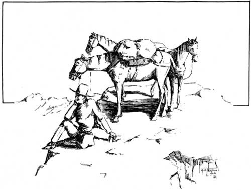
In the summer of 1925 I made a trip through part of it and I believe it was one of the most interesting mountain trips I have ever made. Perhaps because, due to the bigness of the country, I had a feeling of being the only one in it. True there are not many travelers in that part of the world, nevertheless it has been pretty well explored at different times for many years back.
I was convinced that there was a passage around to Goat Flat, a high extensive plateau, by following the main divide from Union Peak south, and then across onto this plateau and thence on down by Torrey Lakes and back, making a complete circle. Accordingly I started out with one pack and two saddle horses and traveled west and south to Union Peak, having several odd jobs to attend to in the intervening country. Camping on the southeast side of Union Peak I surveyed with field glasses the country over which I proposed going.
From this point the route looked easy. There seemed to be nothing that would greatly interfere with horse travel. The country appeared rolling for many miles, well above timber line at an average elevation of 12,000 feet. I smoked my pipe in peace and went to bed secure in the belief that on the morrow I would travel down that rolling stretch of country and reach my destination in good time. My three horses were in good shape and every confidence was felt that here was a short route down the continental divide which had not been traveled by horses before, but which would prove a quick way of getting from the west side of the district to the Torrey Creek and Dinwoody side.
It was clear that there was one or two severe canyons to cross from Union Peak to the main saddle or hog back. Crossing over the head of Jakey's Fork with some difficulty I climbed to that long rolling ridge, and towards evening of the next day found myself traveling down it in a southeasterly direction. But at the start I found one thing that had not been reckoned on and that was the condition of the ground. It was very soft, so soft in fact that the horses went in very near to their knees. And that was not all of it. This ground, if such it can be called, was mostly stones; small, unevenly shaped stones about the size of an egg with just enough earth mixed in to make sort of a resemblance to wet concrete, and there was an occasional conglomerate mass of rock. My progress was slow and by late evening only a small part of the country had been traversed.
A heavy storm was approaching and I was anxious to get some place where feed for my horses and wood for a camp fire could be found. A wide detour to the east was made. There was a canyon at least two thousand feet deep in that direction but I was in hopes of finding a way down far enough at least for feed and wood, since it was getting very cold. A slight dip of perhaps one hundred feet let me down to the wall of the canyon which fell off abruptly from this point and it was nowhere possible to go any further. Too late to turn back, to retrace any of my journey of the day, the packs were pulled and I stopped, turning all horses loose.
Like a cyclone the heavy wind and storm burst full upon the camp and there was nothing else to do but sit upon that exposed point and watch the lighting apparently strike all around, with the following reverberating crash of thunder. The horses were badly worn and frightened and one seemed to pay much attention to the close flashes of lighting which at times were so bright that they caused me to "blink" my eyes.
To one who has not camped alone amid the high peaks, it is quite impossible to describe the feeling that comes over one in such a dreary waste of land as this. Everywhere rocks, cold and grey interspersed with snow banks and glaciers. No sign of life anywhere evident and one feels as though he had been removed to a dead world. A planet such as ours may have been aeons ago. A feeling of utter loneliness and such loneliness as I have never felt before—as though every living soul had left and gone to a brighter world. A feeling of smallness which is indescribable, and yes, a feeling of reverence for the Creator, as though He alone had His eyes upon me and that I was being judged close in His presence. I crawled into my blankets and slept.

Brooks Lake Country (Courtesy of the Highway Dept.)
The following morning I breakfasted on bread, cheese, and water. Try it sometime, it isn't bad when you're feeling good. The horses stood on a small point where there was a little moss, hunched up in a manner similar to stock in the winter. The night had been very cold and the ground and rocks were covered with a thin sheet of ice; light snow and heavy rain from the night before and the natural wetness from melting snows. I was on my way shortly after the sun had risen which was trying its best to get this cold bleak ridge into some semblance of a summer day. I traveled south.
Soon the soft ground was passed entirely and in its place was a jumble of large boulders broken only by interspersing snow banks. All of the boulders in the world, apparently. Progress was slow. Walking ahead a little way I would pick a route, then return and lead one horse at a time through it. Perpetual snow drifts were very encouraging because a horse can travel these without any difficulty. All horses had early on the trip lost all shoes in the soft ground.
Towards evening I crossed a very large glacier on the heads of both Torrey Creeks and under Down's Mountain. The crossing took an hour and a half and some idea of the size can be obtained, though of course progress was slow. It was extremely steep on the north side while going down but the loose snow on top made it possible for the horses to hold their footing in good shape. An interesting thing here, I thought, was one of the walls on the northeast side of Down's Mountain. Ice was so smoothly imbedded in this perpendicular wall that the various cracks and ridges running both vertically and horizontally gave it the appearance of a building with many small panes of glass in its windows. In fact it compared favorably with a large factory building.
Streams were running across the bottom of the glacier and they were no different than ordinary mountain streams, except the absence of any vegetation whatever. The banks were about eighteen inches high and were of blue ice and the stream beds—they were of glassy blue ice and resembled for all the world a child's toy of imitation glass water.
I camped again that evening—rather had best say stopped because there was not much of a camp to it. My tender footed horses were given a snow bank to stand on in preference to the cruel jagged rocks which were everywhere. No feed for them again and I was very anxious about them.
The following day I ascended Goat Flat and traveled easterly. This was indeed a mass of boulders with very little interspersing snow. Tiny patches of grass presented themselves occasionally amidst the rocks and boulders. Clouds hung heavily all morning and particularly to the west where the principal peaks of the state are situated.
Towards evening while scanning the western horizon the clouds lifted gently, and there, like some grand old patriarch with his cap of snow set at a rakish angle, enthroned amongst shimmering ice and towering crags stood the mountain monarch of Wyoming—Gannett Peak. From this point it stood out in all its significance and is at once recognized as the highest peak in the surrounding range. Here was found a small patch of feed—it was short grass but green and sweet and the horses surely reveled in it.
That evening Goat Flat was crossed and camp was made at a small patch of timber on the Torrey Creek drainage. How good those trees looked and the abundant short grass surrounding them. For a while I felt as though I was again in the heart of the forest in spite of the fact that this was on the extreme upper edge of timber line. And I could not help but think of what a horrible place this world would be if trees were taken away from us.
From Down's Mountain south for approximately twelve miles lies the big Wyoming glacial field. The Dinwoody and Bull Lake glaciers are the largest but there are many others of sufficient size to stir the blood of most any alpine climber. The whole country is a spectacular one. It presents a sight that is at once grand and cruel, cold and magnificent, gorgeous in its very formidableness. Wyoming at its source, perhaps, yet Wyoming in all its inimitable strength and ruggedness.
And what does a ranger do besides run around over the landscape and enjoy the scenery? I wonder how many times I have been asked that question. Sometimes people are blunt and frankly want to know what we do to kill time. There are several things that a district ranger must do. Everything is done that can possibly be thought of to keep people mindful of the danger resulting from carelessness with fire, matches, cigarettes and what not while in the woods. You see carelessness in these lines is what causes 75% of the fires. Signs are put up and lectures are given. Then there is the preparation of those fire plans before mentioned. We stir up all of the local interest we can in this kind, as well as interest that isn't local. And we always try to apprehend parties starting fires regardless of the size of the fire (or the person either). We count cattle and sheep that graze upon the forest; we make divisional boundaries in the various range allotments and examine the range to prevent overgrazing or under grazing. We try to become familiar with stockmen's wants and so allot range that will advance forestry and meet his needs as well. We carry on grazing studies and use the knowledge gained in trying to give better administration. We mark timber for cutting and then scale it after it has been cut. This in itself is no mean job when there is one or more timber sales on an average district. We survey and locate trails, then organize trail crews and direct the work of constructing them. We select sites for summer homes and sites for public camp grounds, then try our hardest to get the traveling public to use them so that the fire danger will be reduced through the centralization of travel. Sites for cabins, corrals, pastures, and other uses when applied for, must first be looked over and reported on by the ranger; after that he has to look the property over every year to see that it is kept in the way it should be—neat and sanitary.

Wind River Mt. Range (Courtesy of the Agricultural Dept.)
We make game counts where we can and become as familiar with wild life as our time will permit, and we aid the state in the enforcement of the game laws. But why go on? There is such a vast medley of jobs to be done on the average district that it would become burdensome to enumerate them all. For instance such jobs as keeping accounts of various expenditures, the daily writing of a diary (including Sunday), and the distribution of the time spent during the day, on an hourly basis, to one or more of twenty-nine standard activities; various reports at the end of each month; repairs to headquarters buildings and maintenance of them to say nothing of the care of horses and generally a car. Checking over the property, and Uncle Sam is very particular about his tools and various equipment, keeping them in shape and keeping fire tool caches which are scattered around over the mountains at numerous points, up to certain necessary standards and in readiness for instant use. There are jobs that come up from day to day that are not enumerated.
Then there are the telephone systems—but I am going no further. Enough is sufficient. We have plenty to do. What's more, we have to do it, because we have a pretty good system of inspections from those higher up and alibis sometimes are hard to find.
Some call this the forest primeval—perhaps it is in more ways than one, irrespective of the changes that have taken place. True, trees have been cut—trails have been built—cattle and sheep have trodden it, and in places, fire has scorched it. But the very bigness of it dwarfs man's attempts to greatly change it. As a matter of fact he doesn't try—his duty is to keep it and improve it where he can. Trees, grass, flowers; alpine lakes and riotous mountain streams, and back of these the massive peaks capped with snow and ice forever reminding us of the dim long ago. Trees have grown to maturity and died. Grass and flowers bloom and fade and the wild life goes serenely on its way, ever dependent upon the forest for its shelter and livelihood, much the same as people have come to look to it for a large portion of their livelihood.
And lest we forget, will you please remember about that camp fire, that match, that cigarette, pipe, or cigar, when you are next in the woods?