Results and Discussion
Data Base
A total of 889 individual fire scars (from 171 trees) were documented in the 3 study areas; 726 of these occurred in the 1735 to 1900 period. Ponderosa pine (Pinus ponderosa), Douglas-fir (Pseudotsuga menziesii), western larch (Larix occidentalis), lodgepole pine (Pinus contorta), and whitebark pine (Pinus albicaulis) all had multiple fire scars dating back as far as 250 to 300 years, although in most areas the lodgepole pine fire-scar records extended back only 150 to 200 years because of stand ages. Ponderosa pine provided the clearest, most abundant, and oldest records in all study areas, with scars as old as 400 years.
The data base is displayed in tables A-1, A-2, A-3, and accompanying figures A-1, A-2, A-3 (appendix A) Table A-1 is the master fire chronology for the Onehorse area, showing the number of sample trees scarred during each fire year in each stand. Figure A-1 shows the locations of those stands and of the sample trees within them. Similarly, the paired fire chronologies and maps present the data for Tolan (table A-2 and fig. A-2) and West Fork (table A-3 and fig. A-3).
Fire Frequency
It seems apparent from tables A-1, A-2, and A-3, and especially as the total number of fire scars per study area is graphed in comparison with sample size in figure 2, that the fire frequencies remained comparably high as far back as the records go—namely, to the early 1600's at Tolan and West Fork and to about the year 1500 at Onehorse. Thus it appears that the fire frequencies during the 1735 to 1900 period represent a pattern continuing back at least to the year 1600.
A logical question that arises is how frequencies based on 200- to 800-acre stands compare with those obtained at a single point on the ground, a single tree. As an example, figure 3 shows the scarred cross section of a ponderosa pine growing on the "montane slopes" (table 1, column 2) at Onehorse. During the 1735 to 1900 period it was scarred by 15 fires at an average interval of every 11 years. This compares with an average interval of 7 years for stands in that category (table 1) at Onehorse. Trees growing only a few dozen yards from the one in figure 3 had scars from additional fires. It seems highly unlikely that every fire could burn hot enough at the base of any given tree in such a stand to inflict a new wound, especially when they occurred so frequently as to allow only light accumulations of fuel.
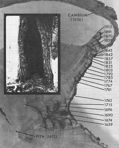
Figure 3.—Multiple fire-scar cross-section, showing 21 fire scars from 1659 through 1915. (Ponderosa pine sample tree #3, Onehorse study area, Bitterroot National Forest)
Fires occurred less often in the Tolan and West Fork areas (table 1); thus one might expect individual trees there to be exposed to more intense fires which are more likely to cause a scar. Average pre-1900 fire-free intervals were calculated for the most frequently scarred individual trees in each habitat-type group. These intervals proved to be only about 15 to 20 percent longer than those derived for the entire 200- to 800-acre stands. Even these trees might have missed being scarred in one or two fires, confirming the stand-based estimates.
These historic fire frequencies are compared in table 1 by habitat-type groups for each of the three study areas. For instance, stands on the montane slopes (Pseudotsuga/Physocarpus and other habitat types) had average intervals of 16 and 19 years between fires in the Tolan and West Fork areas, respectively. The shortest interval detected between fires in any of the three stands in this category at Tolan was 4 years. The longest fire-free interval there, during this 1735 to 1900 period, was 29 years. During this period the dominant overstory species was ponderosa pine (table 1, column 5); whereas Douglas-fir would dominate in the absence of fire or other disturbance (column 4). Comparable interpretations can be made for other habitat types using table 1.
Inspection of table 1 reveals that the relative fire frequencies by forest categories are nearly identical at Tolan and West Fork. By contrast, fires occurred almost twice as frequently throughout the Onehorse area—except for the upper subalpine slopes where the sample size was very small, and probably inadequate. One could argue that the Onehorse area is basically drier and therefore burns more frequently, but this reasoning is not borne out by field observations or by the standardized habitat-type categories. A more plausible explanation is that fires originating on the lower slopes at Onehorse spread more readily upward throughout all the types because of the steep topography. However, the data in table 1 show that fire frequencies decrease with increasing elevation at Onehorse at a rate comparable to that of the other areas. Also, such an explanation fails to account for the high frequency of fires on the lowermost units at Onehorse.
Several threads of evidence suggest another reason for the higher fire frequency at Onehorse. Anthropologists have long recognized that Indians historically set fires in the Rocky Mountains (Malouf 1969). Direct descendants of the first settlers in the Sula Valley below Tolan study area (Marvin and William Wetzsteon at Sula, and Mr. Lord at Moosehead Museum, north of Sula, 1975, personal communication.) stated that when their grandparents homesteaded the area near the turn of the century, Indians periodically set forest fires in the nearby mountains, presumably to improve forage production for big game and horses. Indians occupied the Bitterroot Valley for at least several centuries prior to white settlement in the mid-1800's (Ward 1973). According to Dr. C. Malouf, University of Montana, Missoula (personal communication) Indians preferred the main Bitterroot Valley grasslands adjacent to the Onehorse area, therefore aboriginal burning probably would have been more common here than on the rather remote Tolan and West Fork study areas.
Still another tentative suggestion of deliberate aboriginal burning has arisen from Mehringer's (1976) analysis of 12,000 years of pollen and charcoal deposition at Lost Trail Pass Bog (located in the "lower subalpine slopes" category, table 1) 7 miles southwest of the Tolan study area. Mehringer found that airborne charcoal has been deposited continually since the reestablishment of vegetation in the area after glacial retreat 11,500 years ago. Presumably this came from fires burning in a sizable, mostly forested region upwind from Lost Trail Pass. However, the magnitude of charcoal deposition increased dramatically within the last 2,000 years despite no marked change in the forest type. To keep this idea in perspective, one must realize that to hypothesize an Indian-burning program from deposition in one bog is a large extrapolation.
Correlations Among Fire Years
Comparison of the Onehorse data with National Weather Service records between 1870 and 1920 revealed that fires were strongly correlated with drier-than-average summers (Arno, footnote 1). Table A-4 (appendix A) depicts apparent correlations among the fire years on the three study areas. Evidently, rather extensive fires occurred simultaneously on at least two of the areas during the following years:
| 1892 | 1785 |
| 1889 | 1766-67 |
| 1870-71 | 1751-52 |
| 1862-63 | 1720 |
| 1858 | 1715 |
| 1846-47 | 1695-96 |
| 1828 | 1667-68 |
| 1802-03 | 1631-32 |
Table A-4 also shows that there were a number of years when one area was burned extensively, while the others evidently experienced little or no fire.
Extent and Severity of Fires
It is much more difficult to quantify the intensities of historic fires than it is to simply document their occurrence and determine fire frequency. Still, several sources of data can be interpreted to provide an understanding of the historic role of fire.
Implications of Fire Frequency
The relatively short intervals between fires throughout the three study areas (table 1) suggest that fire intensity was not usually great because there was little time for heavy fuel accumulation.
Age-class Findings
The r's in table A-2, for example, show that many age classes of shade-intolerant conifers were detected wherever age-class analysis was conducted (all stands except A and I) (Some of the regeneration data in table A-2 were provided by Ed Mathews, Northern Forest Fire Laboratory, Missoula, Montana.) Less intensive age-class sampling was done at Onehorse and West Fork, but nevertheless the r's in tables A-1 and A-3 show a similar pattern of multiple age classes of shade-intolerant conifers. Each age class was rather easy to relate to a fire that occurred from 3 to 10 years prior to establishment of the oldest trees in that class.
Some of the age classes detected in a stand apparently resulted from a fire that was not represented as a scar on sample trees in that stand. Fire years 1811 and 1871 in stand F (table A-2) are examples. When the adjacent stands (E and G) had both scars and regeneration dating from those fire years, it seems likely that the fire had in fact visited the stand in question (stand F).
Evidence of Fires of Various Intensities
Both field observations and table A-2 (stand D, 1821 and 1871) suggest that some fires were of such low intensity that little of the lodgepole pine overstory was killed and the stand was not opened sufficiently to allow for establishment of a new age class. This is evidence of a low-intensity, creeping ground fire in lodgepole pine stands. Similar evidence was also observed in many lodgepole forests in all but the northwestern part of Montana during field studies for the forest-habitat-type classification system (Pfister and others, in press). In northwestern Wyoming, Loope and Gruell (1973) found evidence of the historic role of creeping ground fires in lodgepole pine forests. Moreover, they stated that even under high fuel loadings recent fires have remained generally on the ground except when encountering strong winds or extremely heavy loadings. Moderate upslope winds on steep forested slopes may produce the same effect as strong winds on more gentle terrain.
In general, these interpretations for the Montana portion of the Bitterroot National Forest differ from the view presented by Wellner (1970) that fire damage was "usually extreme" in all major forest ecosystem types in the Northern Rocky Mountains except where ponderosa pine and sometimes where Douglas-fir is the potential climax. The abundance of trees with many fire scars in addition to multiple age classes over most of the landscape in the three study areas suggests that usually fire damage was not extreme.
Forests in the Montana portion of the Bitterroot National Forest are generally less productive and probably less dense than in northern Idaho where Wellner's conclusions seem most applicable. Terrain is often steep, in the Bitterroot especially on the montane slopes (Pseudotsuga habitat types, table 1) favoring more-intense burning. However, comparable exposures in northern Idaho, characteristically have more densely forested western hemlock (Tsuga heterophylla), western redcedar (Thuja plicata), or grand fir (Abies grandis) habitat types; that are evidently more likely to burn in stand-destroying fires. Large holocausts (1910, 1919, Pete King fire in 1934, Sundance and Trapper Peak fires in 1967) have occurred in northern Idaho in this century.
Most researchers are strongly tempted to generalize about fire behavior but perhaps fires in the Northern Rockies are not best described in broad generalizations. Detailed studies of fire history at various places throughout our forest types should ultimately resolve this problem.
Gabriel (1976) recently completed a detailed analysis of the fire history in some lodgepole pine-dominated forests in the Bob Marshall Wilderness of northwestern Montana. In the southern half of his study area, Gabriel documented the occurrence of low-intensity surface fires at 20- to 40-year intervals in each stand. By contrast, he found that larger, stand-destroying fires had profoundly influenced most of the northern half of his study area. However, even here he found about 20 living lodgepole pine and Douglas-fir trees having two fire scars each. This suggests a sporadic pattern of stand destruction even during relatively high intensity fires.
A small proportion of the Onehorse and Tolan areas and a sizable part of the western unit of the West Fork area were apparently burned in high-intensity fires. At Onehorse a fire-killed stand evidently resulted from a double burn in 1889 and 1892 (Arno, footnote 1). At West Fork a sizable stand was killed in 1889. At Tolan a stand was killed at the head of the canyon bottom (between stands F, G, and H, fig. A-2) in 1785 on a site that was unique in having no evidence of fire having visited it since. In all study areas, the holocaust was restricted to areas within the lower subalpine forest dominated by lodgepole pine (Abies lasiocarpa/Xerophyllum and Abies lasiocarpa/Menziesia habitat types).
Extent of Fires
Mapping every fire that occurred in a given forest area provides insight into the extent and patterns of historic fire (Heinselman 1973). Unfortunately, such mapping, based on the fire scar and age-class data, could not be done at Onehorse because fires were too frequent. At West Fork, sampling was done in stands that were too dispersed over rugged topography to allow for mapping of individual fires. In contrast, the Tolan data was not hampered by those problems, and the age-class data was ample, thus it was possible to plot the extent of each fire detected in the Tolan drainage between 1900 and 1734 (appendix B).
Although many of these fires were not of high intensity, they were not confined to small areas. In contrast, in recent times, fires of low-to-medium intensity are suppressed before they cover large areas, whereas high-intensity crown fires may cover large areas. Observations (Kilgore 1975; Mutch 1974) from areas where natural fires have recently been allowed to run their course (White Cap Area, Bitterroot National Forest; Grand Teton and Sequoia-Kings Canyon National Parks), show that low- to medium-intensity fires may cover large areas by advancing sporadically, often slowly, until heavy fall and winter precipitation finally extinguishes them.
Interpretations
The general pattern of fires and age classes in each stand (tables A-1, A-2, and A-3 is clearly one of frequent fires leaving substantial remnants of earlier age classes. Most pre-1900 fires on the Bitterroot study areas apparently burned lightly on drier slopes at lower elevations, perpetuating ponderosa pine as the dominant species in open stands. These fires killed much of the ponderosa pine regeneration and most of the invading Douglas-fir. Fires tended to burn with greater intensity on north-facing slopes, where dense, young growth of Douglas-fir presented more opportunity for carrying a fire above the ground. Even here, however, much of the old-growth ponderosa pine, Douglas-fir, western larch, and even some lodgepole pine survived. In the lower subalpine forest, dominated by lodgepole pine, fires often were of low or medium intensity, spreading mostly on the forest floor. There were occasional hot spots where a stand was largely killed through bole heating or a "run" through the overstory.
Holocausts have also clearly been a part of the spectrum of fires (Sleeping Child, Saddle Mountain, and Corn Creek fires in 1960 and 1961) occurring on lower subalpine slopes in the Bitterroot. They are unusually intense fires that had a dramatic effect on thousands of acres of forest.
Still higher, in the upper subalpine forest, fires were least frequent and also less intense, probably because of moister and sparser fuels. Some of these latter fires undoubtedly spread upslope from more favorable burning conditions at lower elevations and then burned less intensely as fuels thinned out and moisture increased.